
Terrain
What ground points filtering algorithm is used in LiPowerline software?
- LiPowerline uses an Improved Progressive TIN Densification (IPTD (Zhao et al.,2016) ) filtering algorithm to classify ground points. Specific parameter settings see Classify Ground Points.
The actually scanned LiDAR point density is much larger than the DEM point density requirement of the production. Can data be subsampled?
- If the actually scanned LiDAR point density is much greater than the production demand, you can use the Subsampling tool to subsample the point clouds. This function provides three types of subsampling methods: "Minimum Points Spacing", "Sampling Rate" and "Octree".
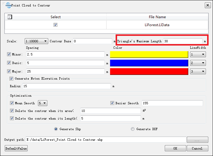
Some of the contour lines generated by the function "Point Cloud to Contour" are broken. Why?
The broken contour lines may be caused by the lack of ground points. The contours can be contiguous by increasing the parameter "Triangle's Maximum Length" on the interface. For example, set 30 meters up to 50 meters or an even larger value.
How to check and improve the quality of DEM generated by LiPowerline?
- You can first create a hillshade map from the hillshade tool in the terrain module. This tool determines the illumination-enhanced surface visualization by setting each cell in the raster. At the same time, you can use Data Management > Conversion > Convert Image to LiModel](../user-manual/DataManagement/Conversion/ConvertImagetoLiModel.md) to convert single-band Tiff images to LiModel. The LiModel can be viewed in 3D and is more intuitive. In addition, the model can be edited by using Terrain > [LiModel Editor, such as "Flatten Height", "Smooth Height", and "Repair Height" to improve the quality of DEM. Similarly, DSM or CHM data can also be operated as above.
	@inproceedings{
	    author={Zhao X Q, Guo Q H, Su Y J and Xue B L},
	    title={Improved progressive TIN densification filtering algorithm for airborne LiDAR data in forested areas},
	    booktitle={ISPRS Journal of Photogrammetry and Remote Sensing,117:79-91},
	    year={2016}
	}