
Classify Ground by Selected
Brief
Due to the complex and varied terrain of point cloud data, it is often difficult to achieve good classification results using a set of parameters when using Classify Ground, especially for the mixed areas (mountains, plains, etc.). This function can reclassify the ground points in the unsatisfactory area.
Usage
First load the data in the window. Click Classify > Classify Ground by Selected, the classification toolbar appears at the top of the data window, as shown below.

From left to right: polygon selection, rectangle selection, sphere selection, subtract selection, clear selection, classify by attribute, conicoid Filte, slope filter, TIN filtering, extract median ground points, recover selection, and exit.
Polygon Selection

Brief: Using method see point cloud selection tool Polygon Selection.
Rectangle Selection

Brief: Using method see point cloud selection tool Rectangle Selection.
Sphere Selection

Brief: Using method see point cloud selection tool Sphere Selection.
Subtract Selection

Brief: Using method see point cloud selection tool Subtract Selection.
Clear Selection

Brief: Clear selected point cloud area.
Classify by Attribute

Brief: Using method see classification tool Classify by Attribute.
Conicoid Filter

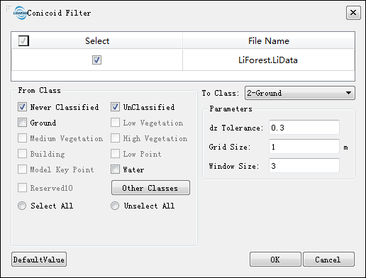
Brief: Ground points are classified by fitting quadric surfaces. The specific idea is: first, mesh the point cloud, select the lowest point of the grid within a certain size window to construct the quadric surface, and compare the distance between the point cloud and the fitting surface in the calculation window and the set distance threshold, which is less than this Thresholds are classified as ground points; otherwise, they are classified as non-ground points. This method is suitable for undulating terrain, but not very steep areas. Click this button, and the dialog as shown below pops up.
Settings
- Input Data: The input file can be a single point cloud data or a point cloud dataset, which must be opened in the LiPowerline software.
- From Class: Source class (es).
- To Class: Target class.
- dz Tolerance (m, default value is"0.3"): After fitting the surface using the grid low point, calculate the height difference between each unclassified point and the surface. If the height difference is greater than the threshold, the unclassified point is classified as non-ground point. Otherwise, it’s classified as ground point.
- Grid Size (m, default value is"1"): The size of the grid that meshes the point cloud. The smaller the grid size, the finer the ground will be fitted, which keeps more details, but the filter efficiency will be a bit affected.
- Window Size (default value is"3"): This function uses a moving window to fit the surface, so the window size directly affects the final filtering result. The larger the window, the larger the area where surface is fitted each time. The grid size and window size need to complement each other for best results.
Slope Filter

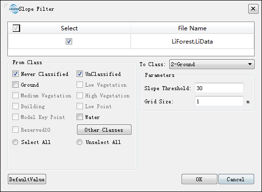
Brief: As the name implies, this filtering method extracts terrain based on changes in point cloud slope. Therefore, its drawbacks are as follows: sensitive to slope change, not reliable in steep areas, and easy to flatten the convex parts on the terrain. This method is more suitable for areas with smooth terrain changes, in that case, the filtering efficiency is high. Click this button, and the dialog as shown below pops up.
Settings
- Input Data: The input file can be a single point cloud data or a point cloud dataset, which must be opened in the LiPowerline software.
- From Class: Source class (es).
- To Class: Target class.
- Slope Threshold (°, default value is"30"): The maximum slope threshold of the slope between grid point and its 8 neighborhood grids. If it is larger than the threshold, it is classified into non-ground points, and vice versa.
- Grid Size (m, default value is"1"): The side length of the grid. In addition, a 3 * 3 grid composes a filter window.
TIN Filter

Brief: Using method see classification tool Classify Ground.
Extract Median Ground Points

Brief: Using method see classification tool Median Ground.
Recover Selection

Brief: Restore last selected point cloud area.
Exit

Brief: Exit this tool bar.
Note: The ground point classification algorithms provided by the selected area point classification include: Conicoid Filter, Slope Filter, and TIN Filter. Different methods should be chosen according to the terrain. Generally, the effect of TIN filter is the most stable and therefore we recommend this first. In addition, it would be better to handle each file seperately.