
Raster Subdivision
Brief
The raster subdivision tool is the inverse operation of raster mosaic. The frame number adapts the coordinate number and consists of the southwest corner of the frame (Y coordinate + X coordinate). A scale of 1:5000 is taken into 1 km, 1:2000 and 1:1000 to 0.1 km, and 1:500 to 0.01 km.
Usage
Click Data Management > Raster Tools > Raster Subdivision
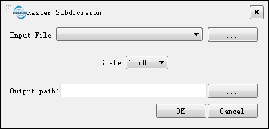
Settings
- Input File: Users can select the file to be processed from the drop-down list.
 : Users can add external files that need to be processed.
- Scale (default "1:500"): Users can select a targeted scale. LiPowerline has four scale options: 1:500, 1:1000, 1:2000, and 1:5000.
- Output path: Path of the output folder. After the algorithm is executed, new subdivided files will be generated.